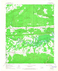
1965 Map of Leflore
USGS Topo · Published 1967About this map
Leflore and Fanshawe anchor this 1960s landscape, where the flat valley of the Fourche Maline gives way to the southern ridges of the Ouachita National Forest. The region is defined by its parallel transportation corridors, with the Chicago Rock Island and Pacific and the St Louis-San Francisco railroads threading between the hills. In the north, the Red Oak Gas Field extends across the terrain near Norris, while the Wister Lake reservoir dominates the east, its shoreline reaching toward the small settlements of Hughes and Summerfield. This map documents a transitional period in eastern Oklahoma, capturing the rural community at Hicks Chapel Cem and the complex drainage of Cedar Creek, Long Creek, and Baker Branch before further modern developments altered the river’s course.
Find a feature on this map
27 named features on this map. Tap any name to fly to it.
Don’t see what you’re looking for? This feature index may not catch every label — zoom into the map to look around manually.
Map Details
Editions of this 1965 Leflore Map
2 editions found
Other maps of this area

1900 · Sansbois
USGS Topo · 1:125,000

1900 · Sallisaw
USGS Topo · 1:125,000

1900 · Winding Stair
USGS Topo · 1:125,000

1901 · Tuskahoma
USGS Topo · 1:125,000

1908 · Tuskahoma
USGS Topo · 1:125,000

1909 · Tuskahoma
USGS Topo · 1:125,000

1909 · Winding Stair
USGS Topo · 1:125,000

1909 · Sans Bois
USGS Topo · 1:125,000

1911 · Sallisaw
USGS Topo · 1:125,000

1911 · Sansbois
USGS Topo · 1:125,000