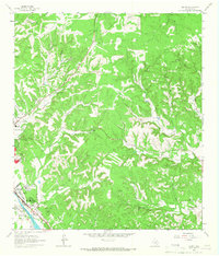
1964 Map of Legion
USGS Topo · Published 1967About this map
The Guadalupe River carves through the Texas Hill Country on this mid-1960s survey, anchoring a landscape where healthcare and public service facilities are central to the local geography. The settlement of Legion is defined by its significant institutional presence, notably the Veterans Hospital and the nearby Lions Camp for Crippled Children. To the northwest, the edge of Kerrville appears with the Peterson Jr High Sch and a specialized Research Lab (USDA).
Find a feature on this map
37 named features on this map. Tap any name to fly to it.
Don’t see what you’re looking for? This feature index may not catch every label — zoom into the map to look around manually.
Map Details
Editions of this 1964 Legion Map
2 editions found
Other maps of this area

1894 · Fredericksburg
USGS Topo · 1:125,000

1894 · Kerrville
USGS Topo · 1:125,000

1954 · Llano
USGS Topo · 1:250,000

1954 · San Antonio
USGS Topo · 1:250,000

1955 · Llano
USGS Topo · 1:250,000

1956 · Comfort
USGS Topo · 1:62,500

1956 · Center Point
USGS Topo · 1:62,500

1956 · Llano
USGS Topo · 1:250,000

1957 · San Antonio
USGS Topo · 1:250,000

1964 · Comfort
USGS Topo · 1:24,000