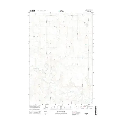
2014 Map of Leith
USGS Topo · Published 2014About this map
Leith stands as the primary settlement in this corner of Grant County, situated amidst a landscape of prairie drainages and gradual rises. The most prominent terrain feature, Spring Hill, overlooks a network of rural roads organized on a strict section-line grid, including 73rd St SW and 60th Ave SW. This 2014 survey documents the geographic relationship between the townsite and the meandering path of the Cannonball River, which snakes across the southern portion of the quadrangle. Local waterways including Boxelder Cr and Morris Cr define the hydrological character of the region, feeding into the larger river basin. The map captures the infrastructure of this agricultural area, from the residential blocks of Leith clustered around Main Ave to the vast stretches of ranch and farmland defined by the surrounding road network.
Find a feature on this map
23 named features on this map. Tap any name to fly to it.
Don’t see what you’re looking for? This feature index may not catch every label — zoom into the map to look around manually.
Map Details
Editions of this 2014 Leith Map
This is the sole edition of this map. No revisions or reprints were ever made.
Other maps of this area

1954 · Bismarck
USGS Topo · 1:250,000

1958 · Bismarck
USGS Topo · 1:250,000

1972 · Carson SE
USGS Topo · 1:24,000

1972 · Leith
USGS Topo · 1:24,000

1972 · Paradise Flats
USGS Topo · 1:24,000

1972 · Wheeler Hills
USGS Topo · 1:24,000

1972 · Pretty Rock Butte
USGS Topo · 1:24,000

1972 · Sheep Creek Dam
USGS Topo · 1:24,000

1980 · Heil
USGS Topo · 1:24,000
1980 · Elgin
USGS Topo · 1:24,000