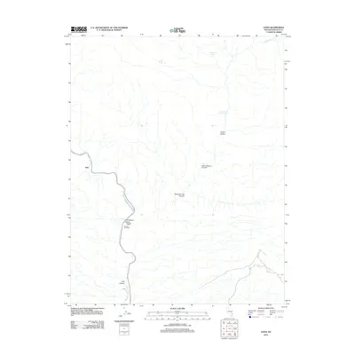
2012 Map of Leith
USGS Topo · Published 2012About this map
Meadow Valley Wash carves a critical north-south corridor through this portion of Lincoln County, dictating the placement of the area's few settlements and roads. The map highlights the reliance on specific water sources in this arid environment, naming scattered features such as Mudhole Spring, Oil Spring, and the optimistically named Fountain of Youth Spring. Human activity is concentrated along the wash, where the Kiernan Ranch and its associated Kiernan Post Office serve as a primary landmark for local history and genealogy research. Further south, the settlement of Leith sits near the mouth of Leith Canyon, while Kyle marks an upstream point of interest. The landscape is defined by its drainage systems, including Horse Springs Canyon and Cottonwood Canyon, which feed into the central wash. This survey documents the persistent but sparse infrastructure of the region, where named canyons and reliable springs remain the most significant orienting features.
Find a feature on this map
14 named features on this map. Tap any name to fly to it.
Don’t see what you’re looking for? This feature index may not catch every label — zoom into the map to look around manually.
Map Details
Editions of this 2012 Leith Map
This is the sole edition of this map. No revisions or reprints were ever made.
Other maps of this area

1885 · Pioche
USGS Topo · 1:250,000

1886 · Pioche
USGS Topo · 1:250,000

1954 · Caliente
USGS Topo · 1:250,000

1959 · Caliente
USGS Topo · 1:250,000

1969 · Elgin
USGS Topo · 1:24,000

1969 · Elgin NE
USGS Topo · 1:24,000
1969 · Vigo NE
USGS Topo · 1:24,000

1973 · Ella Mountain
USGS Topo · 1:24,000
1973 · Leith
USGS Topo · 1:24,000
1973 · Blue Nose Peak
USGS Topo · 1:24,000