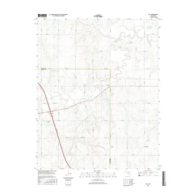
2016 Map of Lela
USGS Topo · Published 2016About this map
The community of Lela sits at the crossing of State Highway 64 and Co Rd 310, marking a central point in this prairie landscape of Pawnee Co and Noble Co. The terrain is defined by the winding course of Black Bear Cr and a series of flood-control reservoirs including Lower Black Bear Cr Site 14 Reservoir and Long Br Cr Site 11 Reservoir. For genealogists and local historians, several burial sites are documented across the rural landscape, including Lela Cem, Morrison Cem, and Union Cem. The Cimarron Tpke cuts diagonally through the western portion of the area, bypassing local landmarks like Knob Hill. Small named localities such as Rambo and a network of section-line roads, such as Diamond Valley and John Wayne, illustrate the persistent grid-based settlement pattern of north-central Oklahoma.
Find a feature on this map
57 named features on this map. Tap any name to fly to it.
Don’t see what you’re looking for? This feature index may not catch every label — zoom into the map to look around manually.
Map Details
Editions of this 2016 Lela Map
This is the sole edition of this map. No revisions or reprints were ever made.
Other maps of this area

1893 · Stillwater
USGS Topo · 1:62,500

1929 · Ripley
USGS Topo · 1:62,500

1930 · Pawnee
USGS Topo · 1:62,500

1932 · Ripley
USGS Topo · 1:62,500

1936 · Pawnee
USGS Topo · 1:62,500

1955 · Enid
USGS Topo · 1:250,000

1958 · Enid
USGS Topo · 1:250,000
1967 · Stillwater North
USGS Topo · 1:24,000

1972 · Morrison NE
USGS Topo · 1:24,000

1972 · Morrison
USGS Topo · 1:24,000