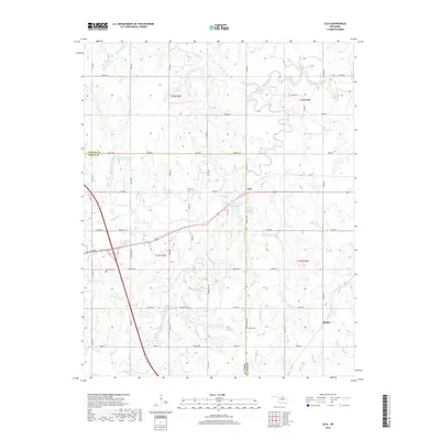
2018 Map of Lela
USGS Topo · Published 2018About this map
Black Bear Cr and its various tributaries define this section of the Oklahoma landscape where Noble Co and Pawnee Co meet. The settlement of Lela sits as a central junction along the northern reaches of the creek, surrounded by a grid of named rural roads including Maverick Rd and John Wayne. The area's agricultural and local heritage is preserved through several community landmarks, such as Lela Cem, Morrison Cem, and Union Cem, which serve as vital points for genealogical research. Prominent local terrain features like Knob Hill and the Diamond Valley break the plains, while numerous small reservoirs and drainage systems like Turkey Cr, Lion Cr, and Panther Cr highlight the region's focus on water management and land use.
Find a feature on this map
44 named features on this map. Tap any name to fly to it.
Don’t see what you’re looking for? This feature index may not catch every label — zoom into the map to look around manually.
Map Details
Editions of this 2018 Lela Map
This is the sole edition of this map. No revisions or reprints were ever made.
Other maps of this area

1893 · Stillwater
USGS Topo · 1:62,500

1929 · Ripley
USGS Topo · 1:62,500

1930 · Pawnee
USGS Topo · 1:62,500

1932 · Ripley
USGS Topo · 1:62,500

1936 · Pawnee
USGS Topo · 1:62,500

1955 · Enid
USGS Topo · 1:250,000

1958 · Enid
USGS Topo · 1:250,000
1967 · Stillwater North
USGS Topo · 1:24,000

1972 · Morrison NE
USGS Topo · 1:24,000

1972 · Morrison
USGS Topo · 1:24,000