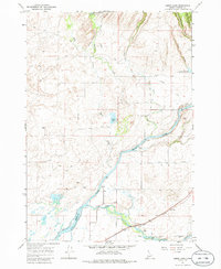
1965 Map of Lemon Lake
USGS Topo · Published 1986About this map
Henrys Fork and the Falls River converge in this corner of Idaho, creating a landscape defined by an intricate network of irrigation and water management. Collected in the mid-1960s, the data shows a complex system of waterways including the Arcadia Canal, Farmers Own Canal, and the Last Crosscut Canal. These features, along with several Gaging Stations and a Diversion Dam, illustrate the vital role of water rights and agricultural engineering in Fremont County.
Find a feature on this map
27 named features on this map. Tap any name to fly to it.
Don’t see what you’re looking for? This feature index may not catch every label — zoom into the map to look around manually.
Map Details
Editions of this 1965 Lemon Lake Map
2 editions found

Other maps of this area

1949 · Newdale
USGS Topo · 1:24,000

1950 · Newdale
USGS Topo · 1:24,000

1950 · St Anthony
USGS Topo · 1:24,000

1955 · Ashton
USGS Topo · 1:250,000

1955 · Driggs
USGS Topo · 1:250,000

1958 · Driggs
USGS Topo · 1:250,000

1958 · Ashton
USGS Topo · 1:250,000

1960 · Ashton
USGS Topo · 1:250,000

1962 · Driggs
USGS Topo · 1:250,000
1965 · Black Knoll
USGS Topo · 1:24,000