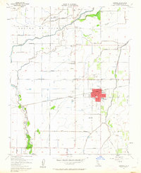
1954 Map of Lemoore
USGS Topo · Published 1963About this map
The Kings River drainage dominates this San Joaquin Valley landscape, where the branching forks and sloughs of the Laguna De Tache grant reveal an intricate system of water management. The 1954 field check captures the city of Lemoore during a period of agricultural stability, showing the town center organized around the Southern Pacific tracks and local landmarks like the High School and City Hall. Beyond the urban core, the landscape is a grid of irrigation and transport, marked by features like the Flint Ave Canal and the Lower Kings River Ditch.
Find a feature on this map
46 named features on this map. Tap any name to fly to it.
Don’t see what you’re looking for? This feature index may not catch every label — zoom into the map to look around manually.
Map Details
Editions of this 1954 Lemoore Map
4 editions found
Other maps of this area

1924 · Riverdale
USGS Topo · 1:31,680

1926 · Hanford
USGS Topo · 1:31,680

1926 · Lethent
USGS Topo · 1:31,680

1927 · Laton
USGS Topo · 1:31,680

1927 · Burrel
USGS Topo · 1:31,680

1927 · Riverdale
USGS Topo · 1:31,680

1927 · Lemoore
USGS Topo · 1:31,680

1929 · Guernsey
USGS Topo · 1:31,680

1929 · Stratford
USGS Topo · 1:31,680

1929 · Westhaven
USGS Topo · 1:31,680