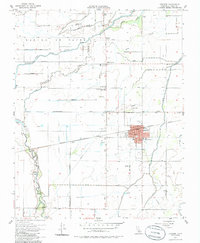
1954 Map of Lemoore
USGS Topo · Published 1986About this map
Lemoore serves as the central hub of this 1950s agricultural landscape, where the Southern Pacific railroad cuts through a grid of rural avenues and irrigation ditches. The town's expansion is evident in the detailed street plan and prominent High School, while the surrounding land reflects the heavy reliance on the complex water systems of the Kings River and its various branches. Historical roots are anchored by the El Adobe De Los Robles Historic Marker and the rural Island Sch, situated among the various farmsteads and agricultural plots of the Laguna De Tache. The map details the transition from natural features like Crooked Slough to man-made infrastructure such as the Lower Kings R Ditch and the Landing Strip north of the main settlement. This survey, updated with 1950s aerial photography, captures the Kings County countryside during a period of steady post-war development.
Find a feature on this map
38 named features on this map. Tap any name to fly to it.
Don’t see what you’re looking for? This feature index may not catch every label — zoom into the map to look around manually.
Map Details
Editions of this 1954 Lemoore Map
4 editions found
Other maps of this area

1924 · Riverdale
USGS Topo · 1:31,680

1926 · Hanford
USGS Topo · 1:31,680

1926 · Lethent
USGS Topo · 1:31,680

1927 · Laton
USGS Topo · 1:31,680

1927 · Burrel
USGS Topo · 1:31,680

1927 · Riverdale
USGS Topo · 1:31,680

1927 · Lemoore
USGS Topo · 1:31,680

1929 · Guernsey
USGS Topo · 1:31,680

1929 · Stratford
USGS Topo · 1:31,680

1929 · Westhaven
USGS Topo · 1:31,680