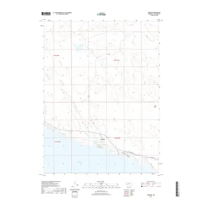
2017 Map of Lemoyne
USGS Topo · Published 2017About this map
Lemoyne sits on the northern shore of the expansive Lake McConaughy in Keith County, serving as a focal point for this Nebraska landscape. The settlement is defined by its proximity to the water, with Lemoyne Rd and N Shore Rd tracing the irregular coastline. The terrain north of the lake is characterized by the drainage of Lonergan Creek and the presence of Berry Lake, surrounded by a network of rural routes like Berry Rd. This area illustrates the late-20th and early-21st-century development of the region's recreational and agricultural interface, where the shoreline is dotted with named areas such as Sandy Beach and Bay Meadows. To the east, the depression of Ackley Valley transitions away from the immediate lakefront, showing the varied topography that borders the North Platte River valley's massive reservoir system.
Find a feature on this map
16 named features on this map. Tap any name to fly to it.
Don’t see what you’re looking for? This feature index may not catch every label — zoom into the map to look around manually.
Map Details
Editions of this 2017 Lemoyne Map
This is the sole edition of this map. No revisions or reprints were ever made.
Other maps of this area

1897 · Ogallala
USGS Topo · 1:125,000

1900 · Ogallala
USGS Topo · 1:125,000

1954 · North Platte
USGS Topo · 1:250,000

1956 · North Platte
USGS Topo · 1:250,000

1957 · North Platte
USGS Topo · 1:250,000

1967 · North Platte
USGS Topo · 1:250,000

1971 · Martin
USGS Topo · 1:24,000
1971 · Brule NW
USGS Topo · 1:24,000
1971 · Belmar
USGS Topo · 1:24,000
1971 · Bear Hill
USGS Topo · 1:24,000