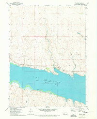
1971 Map of Belmar
USGS Topo · Published 1973About this map
Lake McConaughy dominates the southern half of this Western Nebraska landscape, a massive reservoir on the North Platte River that fundamentally altered the local geography. Along its northern shore, the small community of Belmar sits adjacent to the Union Pacific railroad line, which follows the curve of the water. This era shows the developed recreation infrastructure typical of the early 1970s, including a Boat Ramp, Campground, and several designated Picnic Areas serving visitors to the shoreline.
Find a feature on this map
15 named features on this map. Tap any name to fly to it.
Don’t see what you’re looking for? This feature index may not catch every label — zoom into the map to look around manually.
Map Details
Editions of this 1971 Belmar Map
This is the sole edition of this map. No revisions or reprints were ever made.
Other maps of this area

1897 · Ogallala
USGS Topo · 1:125,000

1900 · Chappell
USGS Topo · 1:125,000

1900 · Ogallala
USGS Topo · 1:125,000

1954 · Scottsbluff
USGS Topo · 1:250,000

1954 · North Platte
USGS Topo · 1:250,000

1956 · North Platte
USGS Topo · 1:250,000

1957 · North Platte
USGS Topo · 1:250,000

1958 · Scottsbluff
USGS Topo · 1:250,000

1967 · North Platte
USGS Topo · 1:250,000
1971 · Brule NW
USGS Topo · 1:24,000