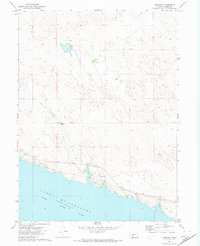
1971 Map of Lemoyne
USGS Topo · Published 1974About this map
Lake Mc Conaughy dominates the southern landscape of this Keith County region, its northern shoreline defining the limits of local settlement and transport. Along this coast, the village of Lemoyne sits as a primary hub where the Union Pacific railroad tracks follow the natural contours of the North Platte River valley. The map reveals a transition from the water-oriented infrastructure to the sprawling uplands of the Nebraska Sandhills, characterized by isolated holdings like Berry Ranch and Baumann Ranch. The presence of Berry Lake and various depressions in the northern interior illustrates the importance of seasonal water and natural wells to these ranching operations. Tracing the path of Lonergan Creek down to the reservoir provides insight into the drainage patterns that shaped the placement of early 1970s roads and property boundaries.
Find a feature on this map
11 named features on this map. Tap any name to fly to it.
Don’t see what you’re looking for? This feature index may not catch every label — zoom into the map to look around manually.
Map Details
Editions of this 1971 Lemoyne Map
This is the sole edition of this map. No revisions or reprints were ever made.
Other maps of this area

1897 · Ogallala
USGS Topo · 1:125,000

1900 · Ogallala
USGS Topo · 1:125,000

1954 · North Platte
USGS Topo · 1:250,000

1956 · North Platte
USGS Topo · 1:250,000

1957 · North Platte
USGS Topo · 1:250,000

1967 · North Platte
USGS Topo · 1:250,000

1971 · Martin
USGS Topo · 1:24,000
1971 · Brule NW
USGS Topo · 1:24,000
1971 · Belmar
USGS Topo · 1:24,000
1971 · Bear Hill
USGS Topo · 1:24,000