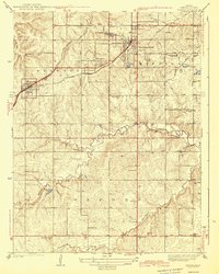
1943 Map of Lenexa
USGS Topo · Published 1943About this map
Lenexa and Overland Park anchor this 1935 survey, which illustrates the transition of Johnson County from rural farmsteads to suburban development. The landscape is defined by the St Louis and San Francisco RR and the Kansas City and Missouri Electric RR, the latter of which cuts through Elmhurst as it connects the growing communities. Numerous one-room schoolhouses, such as Corinth Sch, Oak Grove Sch, and Walnut Grove Sch, are distributed across the Shawnee, Mission, and Oxford townships, marking the educational hubs of the pre-war era. Significant local landmarks like the Mission Valley Hunt Club near Brush Creek and the Antioch Ch north of Nagawika Lake reflect the social and recreational life of the community. The map reveals the intricate drainage patterns of Indian Creek and Tomahawk Creek, providing a detailed view of the natural terrain before modern large-scale residential expansion.
Find a feature on this map
39 named features on this map. Tap any name to fly to it.
Don’t see what you’re looking for? This feature index may not catch every label — zoom into the map to look around manually.
Map Details
Editions of this 1943 Lenexa Map
2 editions found

Other maps of this area

1887 · Olathe
USGS Topo · 1:125,000

1890 · Kansas City
USGS Topo · 1:125,000

1893 · Olathe
USGS Topo · 1:125,000

1894 · Kansas City
USGS Topo · 1:125,000

1934 · Bonner Springs
USGS Topo · 1:48,000

1934 · Grandview
USGS Topo · 1:24,000

1934 · Shawnee
USGS Topo · 1:24,000

1934 · Edwardsville
USGS Topo · 1:24,000

1935 · Olathe
USGS Topo · 1:24,000

1935 · Kansas City
USGS Topo · 1:24,000