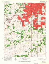
1963 Map of Lenexa
USGS Topo · Published 1964About this map
Overland Park and Prairie Village dominate the northern landscape of this survey, showcasing the rapid suburban expansion of Johnson County in the early 1960s. The red-tinted urban areas reveal a dense network of new schools and civic infrastructure, including the Broadmoor Jr High Sch and Hillcrest Sch, alongside established landmarks like the St Louis-San Francisco railroad line. While the northern half is defined by residential growth, the southern portion in Oxford and Shawnee townships retains a more rural character, marked by winding waterways like Tomahawk Creek and Indian Creek. Notable local landmarks of the era are present throughout, from the Drive-in Theater near Lenexa to scattered oil wells and a gas well in the central corridor. This documentation of the shifting corporate boundary lines provides a clear view of the area's transition from open countryside to an interconnected metropolitan suburb.
Find a feature on this map
68 named features on this map. Tap any name to fly to it.
Don’t see what you’re looking for? This feature index may not catch every label — zoom into the map to look around manually.
Map Details
Editions of this 1963 Lenexa Map
3 editions found
Other maps of this area

1887 · Olathe
USGS Topo · 1:125,000

1890 · Kansas City
USGS Topo · 1:125,000

1893 · Olathe
USGS Topo · 1:125,000

1894 · Kansas City
USGS Topo · 1:125,000

1934 · Bonner Springs
USGS Topo · 1:48,000

1934 · Grandview
USGS Topo · 1:24,000

1934 · Shawnee
USGS Topo · 1:24,000

1934 · Edwardsville
USGS Topo · 1:24,000

1935 · Olathe
USGS Topo · 1:24,000

1935 · Kansas City
USGS Topo · 1:24,000