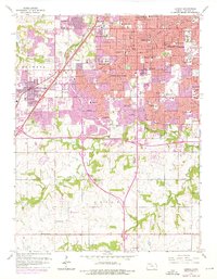
1963 Map of Lenexa
USGS Topo · Published 1976About this map
Overland Park and Shawnee anchor this 1963 survey of Johnson County, which captures a critical period of suburban expansion into Oxford township. The map illustrates a landscape rapidly transitioning from open terrain to a dense network of residential subdivisions, marked by a high concentration of educational and religious institutions such as Shawnee Mission College, KC Bible College, and the Cure of Ars Convent. Significant infrastructure including the Circumferential Freeway and the St Louis-San Francisco railway lines define the transportation corridors through Lenexa and Merriam. Notable local landmarks like the Drive-in Theater, Nagawicka Lake, and several country clubs, including Milburn Country Club and Brookridge Country Club, reflect the mid-century social and recreational development of the Kansas City metropolitan fringe.
Find a feature on this map
72 named features on this map. Tap any name to fly to it.
Don’t see what you’re looking for? This feature index may not catch every label — zoom into the map to look around manually.
Map Details
Editions of this 1963 Lenexa Map
3 editions found
Other maps of this area

1887 · Olathe
USGS Topo · 1:125,000

1890 · Kansas City
USGS Topo · 1:125,000

1893 · Olathe
USGS Topo · 1:125,000

1894 · Kansas City
USGS Topo · 1:125,000

1934 · Bonner Springs
USGS Topo · 1:48,000

1934 · Grandview
USGS Topo · 1:24,000

1934 · Shawnee
USGS Topo · 1:24,000

1934 · Edwardsville
USGS Topo · 1:24,000

1935 · Olathe
USGS Topo · 1:24,000

1935 · Kansas City
USGS Topo · 1:24,000