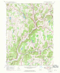
1946 Map of Lenoxville
USGS Topo · Published 1971About this map
Tunkhannock Creek and its many tributaries define the topography of this Susquehanna County region, where the East Branch Tunkhannock Creek joins the main waterway near Glenwood. The landscape is a network of ridges and isolated peaks, including Hickory Ridge, Gunn Hill, and Cobble Hill, which shaped the development of rural settlements like Lenoxville and West Lenox. This survey reflects the mid-century agrarian and residential character of the area, punctuated by small community landmarks such as the West Lenox Ch and Maplewood Cem. Local educational history is preserved through the locations of the Wright Sch and Green Grove Sch, while the presence of the Mount View Airport indicates the modernization of regional transport. Numerous named water bodies like Loomis Lake, Tea Pond, and Robinson Lake suggest a landscape where water resources were vital for both local ecology and community life.
Find a feature on this map
61 named features on this map. Tap any name to fly to it.
Don’t see what you’re looking for? This feature index may not catch every label — zoom into the map to look around manually.
Map Details
Editions of this 1946 Lenoxville Map
3 editions found
Other maps of this area

1892 · Dundaff
USGS Topo · 1:62,500

1932 · Susquehanna
USGS Topo · 1:62,500

1935 · Susquehanna
USGS Topo · 1:62,500

1943 · Montrose
USGS Topo · 1:62,500

1945 · Montrose
USGS Topo · 1:62,500

1946 · Tunkhannock
USGS Topo · 1:62,500

1946 · Dalton
USGS Topo · 1:24,000

1946 · Carbondale
USGS Topo · 1:24,000

1946 · Factoryville
USGS Topo · 1:24,000
1946 · Clifford
USGS Topo · 1:24,000