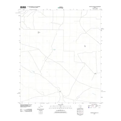
2010 Map of Leoncita Ranch
USGS Topo · Published 2010About this map
Leoncita Ranch stands as a focal point in this portion of the Trans-Pecos, where the arid West Texas landscape is defined by its vital water management features. The ephemeral nature of the drainage system is evident in the paths of Musquiz Creek and Limpia Creek, which cut through the terrain alongside the Upper Coyanosa Draw. Essential for livestock and ranching operations, artificial water sources like Benson Tank and Big Tank are mapped alongside the Waldo Windmill, illustrating the infrastructure required for life in this dry environment. Access across the ranch lands is primarily provided by Hovey Rd, which traverses the eastern section of the quadrangle, linking this remote ranching area to the broader regional network during the early 21st century.
Find a feature on this map
9 named features on this map. Tap any name to fly to it.
Don’t see what you’re looking for? This feature index may not catch every label — zoom into the map to look around manually.
Map Details
Editions of this 2010 Leoncita Ranch Map
This is the sole edition of this map. No revisions or reprints were ever made.
Other maps of this area

1894 · Fort Davis
USGS Topo · 1:125,000

1897 · Fort Davis
USGS Topo · 1:125,000

1929 · Hovey
USGS Topo · 1:125,000

1954 · Fort Stockton
USGS Topo · 1:250,000

1958 · Fort Stockton
USGS Topo · 1:250,000

1970 · Deep Well Ranch
USGS Topo · 1:24,000

1970 · Deep Well Ranch SE
USGS Topo · 1:24,000

1973 · Fort Stockton
USGS Topo · 1:250,000

1980 · Hovey
USGS Topo · 1:24,000
1980 · Barrilla Mountains East
USGS Topo · 1:24,000