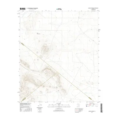
2016 Map of Leoncita Ranch
USGS Topo · Published 2016About this map
Leoncita Ranch anchors this high-desert landscape where three West Texas counties converge. The terrain is defined by the steep relief of unnamed peaks and the drainage patterns of seasonal waterways like Upper Coyanosa Draw and Musquiz Creek. In an arid environment where water dictates the location of human activity, Leoncita Spring and Benson Tank represent critical resources for ranching operations. The quadrangle captures the remote intersection of Pecos, Jeff Davis, and Brewster counties, with Hovey Rd providing the primary corridor through the northern sections. This 2016 survey illustrates the persistent importance of isolated springs and drainage basins in the Trans-Pecos region, where modern property boundaries and ancient watercourses continue to shape the rural economy.
Find a feature on this map
11 named features on this map. Tap any name to fly to it.
Don’t see what you’re looking for? This feature index may not catch every label — zoom into the map to look around manually.
Map Details
Editions of this 2016 Leoncita Ranch Map
This is the sole edition of this map. No revisions or reprints were ever made.
Other maps of this area

1894 · Fort Davis
USGS Topo · 1:125,000

1897 · Fort Davis
USGS Topo · 1:125,000

1929 · Hovey
USGS Topo · 1:125,000

1954 · Fort Stockton
USGS Topo · 1:250,000

1958 · Fort Stockton
USGS Topo · 1:250,000

1970 · Deep Well Ranch
USGS Topo · 1:24,000

1970 · Deep Well Ranch SE
USGS Topo · 1:24,000

1973 · Fort Stockton
USGS Topo · 1:250,000

1980 · Hovey
USGS Topo · 1:24,000
1980 · Barrilla Mountains East
USGS Topo · 1:24,000