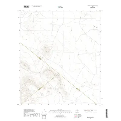
2019 Map of Leoncita Ranch
USGS Topo · Published 2019About this map
Leoncita Ranch anchors this high-desert landscape where three West Texas counties converge. The mapping reveals a complex tri-county boundary where Pecos, Brewster, and Jeff Davis counties meet amidst a system of ephemeral watercourses. This arid terrain is defined by vital water sources like Leoncita Spring and man-made features such as Benson Tank, which support the ranching operations in this isolated portion of the Trans-Pecos. The drainage network includes Upper Coyanosa Draw and Musquiz Cr, illustrating the natural flow of water across the desert floor toward the northeast. Transportation is limited to a handful of paths including Hovey Rd, which cuts through the northern sector of the quadrangle. The elevation contours depict a landscape of broad basins and rising peaks, typical of the mountain-and-basin province near the Davis Mountains.
Find a feature on this map
10 named features on this map. Tap any name to fly to it.
Don’t see what you’re looking for? This feature index may not catch every label — zoom into the map to look around manually.
Map Details
Editions of this 2019 Leoncita Ranch Map
This is the sole edition of this map. No revisions or reprints were ever made.
Other maps of this area

1894 · Fort Davis
USGS Topo · 1:125,000

1897 · Fort Davis
USGS Topo · 1:125,000

1929 · Hovey
USGS Topo · 1:125,000

1954 · Fort Stockton
USGS Topo · 1:250,000

1958 · Fort Stockton
USGS Topo · 1:250,000

1970 · Deep Well Ranch
USGS Topo · 1:24,000

1970 · Deep Well Ranch SE
USGS Topo · 1:24,000

1973 · Fort Stockton
USGS Topo · 1:250,000

1980 · Hovey
USGS Topo · 1:24,000
1980 · Barrilla Mountains East
USGS Topo · 1:24,000