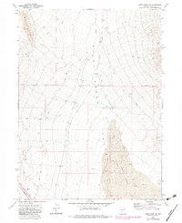
1971 Map of Leppy Peak NW
USGS Topo · Published 1983About this map
Pilot Creek Valley and its surrounding desert terrain dominate this Nevada survey, which captures the area just as aerial photogrammetry was beginning to document the high desert with new precision. The landscape is defined by the shifting geography of the Pilot Sand Dunes and the seasonal waters of Pilot Creek. Human presence is sparse but significant, centered on the Cummings Ranch and the small settlement at Cliffside near the southwestern corner. An Aqueduct and numerous Jeep Trails snake across the basin, indicating the infrastructure required to manage water and transit in this arid environment. The inclusion of industrial features like a Borrow Pit and the Cliffside Well provides a detailed look at the utility of the land during the early 1970s.
Find a feature on this map
13 named features on this map. Tap any name to fly to it.
Don’t see what you’re looking for? This feature index may not catch every label — zoom into the map to look around manually.
Map Details
Editions of this 1971 Leppy Peak NW Map
2 editions found
Other maps of this area

1955 · Wells
USGS Topo · 1:250,000

1955 · Elko
USGS Topo · 1:250,000

1958 · Wells
USGS Topo · 1:250,000

1958 · Elko
USGS Topo · 1:250,000

1961 · Wells
USGS Topo · 1:250,000

1962 · Elko
USGS Topo · 1:250,000

1965 · Elko
USGS Topo · 1:250,000

1967 · Pilot Peak
USGS Topo · 1:24,000
1967 · Pilot Peak SW
USGS Topo · 1:24,000

1967 · Cobre SE
USGS Topo · 1:24,000