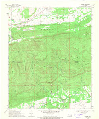
1969 Map of Lequire
USGS Topo · Published 1971About this map
The Sans Bois Mountains and Diamond Mountains dominate this landscape, reflecting the intense natural gas and coal extraction era of the late 1960s. The settlement of Lequire sits at the base of the northern slopes, where a Strip Mine and numerous gas wells point to the region's industrial focus. The map details the transition from the relatively flat terrain of Turkey Flat into the deeply incised valleys of Huckleberry Hollow and Panther Hollow. To the south, the village of Lodi is situated near the Haskell Co Latimer Co boundary, where a network of pipelines cuts through the foothills of Little Yancy Mountain. The presence of scattered Gravel Pit and Shale Pit locations along the creeks suggests a landscape shaped by local materials and energy production during this period.
Find a feature on this map
28 named features on this map. Tap any name to fly to it.
Don’t see what you’re looking for? This feature index may not catch every label — zoom into the map to look around manually.
Map Details
Editions of this 1969 Lequire Map
2 editions found
Other maps of this area

1900 · Sansbois
USGS Topo · 1:125,000

1900 · Sallisaw
USGS Topo · 1:125,000

1900 · Winding Stair
USGS Topo · 1:125,000

1901 · Tuskahoma
USGS Topo · 1:125,000

1908 · Tuskahoma
USGS Topo · 1:125,000

1909 · Tuskahoma
USGS Topo · 1:125,000

1909 · Winding Stair
USGS Topo · 1:125,000

1909 · Sans Bois
USGS Topo · 1:125,000

1911 · Sallisaw
USGS Topo · 1:125,000

1911 · Sansbois
USGS Topo · 1:125,000