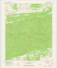
1969 Map of Lequire
USGS Topo · Published 1977About this map
The Diamond Mountains and Sans Bois Mountains dominate the landscape in this late-1960s survey, illustrating the complex geography along the border of Haskell and Latimer Counties. The small community of Lequire serves as a focal point in the northwest, situated near the confluence of several drainages including Turkey Creek and Andrew Creek. Further south, the settlement of Lodi appears near the banks of Red Oak Creek.
Find a feature on this map
26 named features on this map. Tap any name to fly to it.
Don’t see what you’re looking for? This feature index may not catch every label — zoom into the map to look around manually.
Map Details
Editions of this 1969 Lequire Map
2 editions found
Other maps of this area

1900 · Sansbois
USGS Topo · 1:125,000

1900 · Sallisaw
USGS Topo · 1:125,000

1900 · Winding Stair
USGS Topo · 1:125,000

1901 · Tuskahoma
USGS Topo · 1:125,000

1908 · Tuskahoma
USGS Topo · 1:125,000

1909 · Tuskahoma
USGS Topo · 1:125,000

1909 · Winding Stair
USGS Topo · 1:125,000

1909 · Sans Bois
USGS Topo · 1:125,000

1911 · Sallisaw
USGS Topo · 1:125,000

1911 · Sansbois
USGS Topo · 1:125,000