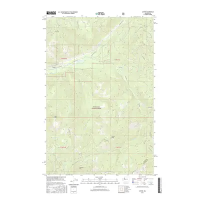
2017 Map of Lester
USGS Topo · Published 2017About this map
Lester sits at the heart of this high-elevation landscape within the Snoqualmie National Forest, positioned where the Green River flows through the steep terrain of the Cascade Range. The map details a complex network of forest development roads, such as Nat For Dev Rd 54, which thread between prominent summits including Bald Mtn and Kelly Butte. The drainage patterns are meticulously recorded, showing numerous tributaries like Friday Cr, Sunday Cr, and Twin Camp Cr feeding into the main river valley. This 2017 survey documents the modern state of this isolated region, tracing the boundary between King and Kittitas Counties along the southern ridges. High points like Colquhoun Peak and the length of Sawmill Ridge define the vertical character of the area, while the presence of Lester Cr and Intake Cr points to the importance of the local watershed.
Find a feature on this map
41 named features on this map. Tap any name to fly to it.
Don’t see what you’re looking for? This feature index may not catch every label — zoom into the map to look around manually.
Map Details
Editions of this 2017 Lester Map
This is the sole edition of this map. No revisions or reprints were ever made.
Other maps of this area

1901 · Snoqualmie Pass
USGS Topo · 1:125,000

1903 · Snoqualmie
USGS Topo · 1:125,000

1913 · Cedar Lake
USGS Topo · 1:125,000

1956 · Greenwater
USGS Topo · 1:62,500

1957 · Wenatchee
USGS Topo · 1:250,000

1960 · Bandera
USGS Topo · 1:62,500

1961 · Snoqualmie Pass
USGS Topo · 1:62,500

1962 · Lester
USGS Topo · 1:62,500

1975 · Snoqualmie Pass
USGS Topo · 1:100,000
1986 · Nagrom
USGS Topo · 1:24,000