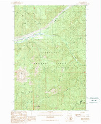
1989 Map of Lester
USGS Topo · Published 1989About this map
Lester stands as a focal point in this late 20th-century survey of the high country in the Cascade Range, situated along the Green River corridor. The map documents a landscape defined by the overlapping boundaries of the Snoqualmie National Forest and the Green River Watershed (City of Tacoma), highlighting the critical role this drainage plays for regional municipal water supply. The terrain is marked by prominent elevations such as Colquhoun Peak, Kelly Butte, and Bald Mountain, with drainage provided by a network of tributaries including Sunday Creek and McCain Creek. A small Landing Strip and various transmission lines indicate the managed nature of this mountain environment, while Sawmill Ridge and scattered pits suggest the legacy of resource extraction and road maintenance in the area north of the King Co / Kittitas Co line.
Find a feature on this map
31 named features on this map. Tap any name to fly to it.
Don’t see what you’re looking for? This feature index may not catch every label — zoom into the map to look around manually.
Map Details
Editions of this 1989 Lester Map
This is the sole edition of this map. No revisions or reprints were ever made.
Other maps of this area

1901 · Snoqualmie Pass
USGS Topo · 1:125,000

1903 · Snoqualmie
USGS Topo · 1:125,000

1913 · Cedar Lake
USGS Topo · 1:125,000

1956 · Greenwater
USGS Topo · 1:62,500

1957 · Wenatchee
USGS Topo · 1:250,000

1960 · Bandera
USGS Topo · 1:62,500

1961 · Snoqualmie Pass
USGS Topo · 1:62,500

1962 · Lester
USGS Topo · 1:62,500

1975 · Snoqualmie Pass
USGS Topo · 1:100,000
1986 · Nagrom
USGS Topo · 1:24,000