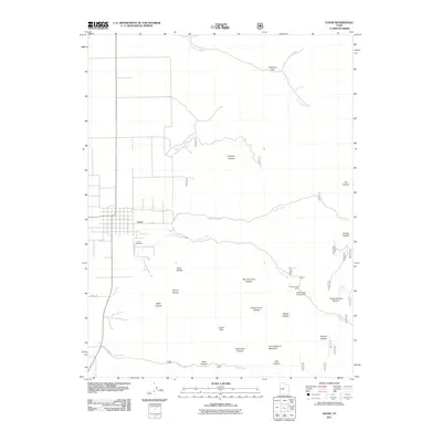
2011 Map of Levan
USGS Topo · Published 2011About this map
Levan sits at the foot of the mountains in Juab County, Utah, where the town’s grid meets the irrigation potential of Chicken Creek and Pigeon Creek. This 2011 survey illustrates the transition from the high-desert valley floor to the prominent peaks of the San Pitch Mountains. Locally significant landmarks like the Levan Cemetery and the thoroughfare of 1st St S anchor the community, while the surrounding terrain is defined by a series of drainage basins including Rock Hollow, Spring Hollow, and Water Hollow. The map provides detailed insight into the recreational and topographical character of the area, showing the location of the Chicken Creek Campground and the significant elevation of Levan Peak. The intricate network of canyons, such as Hartleys Canyon and Deep Canyon, highlights the complex watershed that has historically sustained this rural agricultural settlement.
Find a feature on this map
32 named features on this map. Tap any name to fly to it.
Don’t see what you’re looking for? This feature index may not catch every label — zoom into the map to look around manually.
Map Details
Editions of this 2011 Levan Map
This is the sole edition of this map. No revisions or reprints were ever made.
Other maps of this area

1885 · Manti
USGS Topo · 1:250,000

1895 · Manti
USGS Topo · 1:250,000

1951 · Moroni
USGS Topo · 1:62,500

1951 · Nephi
USGS Topo · 1:62,500

1956 · Price
USGS Topo · 1:250,000

1960 · Price
USGS Topo · 1:250,000

1962 · Price
USGS Topo · 1:250,000

1965 · Chriss Canyon
USGS Topo · 1:24,000
1965 · Skinner Peaks
USGS Topo · 1:24,000

1965 · Wales
USGS Topo · 1:24,000