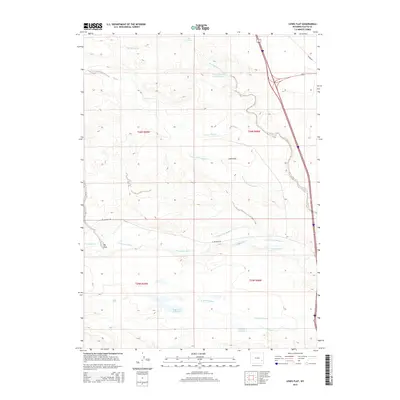
2015 Map of Lewis Flat
USGS Topo · Published 2015About this map
Lewis Flat and the surrounding Platte County landscape are defined by a complex irrigation network developed to support high-plains agriculture. The N Laramie River winds through the southern portion of the quadrangle, serving as the primary water source for an intricate system of man-made waterways, including the N Laramie Canal, Lowica Ditch Number 2, and Mitchell Ditch Number 1. These engineering features reflect the historical necessity of water management in eastern Wyoming, where the natural flow of streams like Fish Cr and Mud Springs Br was augmented to sustain the local economy. In addition to these flowing waters, the map documents several storage sites such as the Loren Ramsey Fish Reservoir, Reservoir Number 1, and Reservoir Number 2. Together with landmarks like Big Draw and Mud Springs, these features illustrate how the terrain has been modified to harness the region's limited water resources.
Find a feature on this map
21 named features on this map. Tap any name to fly to it.
Don’t see what you’re looking for? This feature index may not catch every label — zoom into the map to look around manually.
Map Details
Editions of this 2015 Lewis Flat Map
This is the sole edition of this map. No revisions or reprints were ever made.
Other maps of this area

1896 · Hartville
USGS Topo · 1:125,000

1901 · Hartville
USGS Topo · 1:125,000

1950 · Coleman Butte
USGS Topo · 1:24,000

1950 · Herman Ranch
USGS Topo · 1:24,000

1950 · Cottonwood Falls
USGS Topo · 1:24,000

1951 · Coleman Butte
USGS Topo · 1:24,000

1951 · Cottonwood Falls
USGS Topo · 1:24,000
1951 · Herman Ranch
USGS Topo · 1:24,000

1951 · Dwyer
USGS Topo · 1:24,000
1951 · Wheatland
USGS Topo · 1:24,000