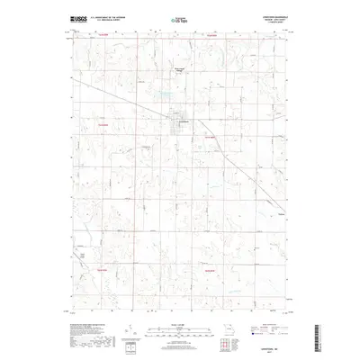
2017 Map of Lewistown
USGS Topo · Published 2017About this map
Lewistown serves as the central hub of this Lewis County landscape, situated at the junction of several key local roads and state highways. The settlement pattern reflects the agricultural character of Northeast Missouri, with established communities like New Court Village to the north and Tolona to the southeast. Water management and rural infrastructure are prominent, evidenced by the City of Lewistown Reservoir and smaller bodies like Baker Lake and Sharpe Lake. The drainage network is defined by the Middle Fabius River and several tributaries including Grassy Cr and Troublesome Cr. Genealogists and local historians will find the Prim Cem in the southeastern quadrant, while the inclusion of Sharpe Farms Airport highlights the intersection of modern agricultural operations and aviation in the region.
Find a feature on this map
64 named features on this map. Tap any name to fly to it.
Don’t see what you’re looking for? This feature index may not catch every label — zoom into the map to look around manually.
Map Details
Editions of this 2017 Lewistown Map
This is the sole edition of this map. No revisions or reprints were ever made.
Other maps of this area

1903 · Kahoka
USGS Topo · 1:125,000

1903 · Palmyra
USGS Topo · 1:125,000

1948 · Quincy
USGS Topo · 1:250,000

1949 · Durham
USGS Topo · 1:24,000

1950 · Durham
USGS Topo · 1:24,000

1950 · Benjamin
USGS Topo · 1:24,000

1950 · Williamstown
USGS Topo · 1:24,000

1950 · Lewistown
USGS Topo · 1:24,000
1950 · Monticello
USGS Topo · 1:24,000

1950 · La Belle
USGS Topo · 1:24,000