1957 Map of Lexington
USGS Topo · Published 1980About this map
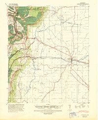
The Illinois Central railroad corridor anchors the western portion of this Holmes County survey, connecting the small settlements of Tchula, Gwin, and Shackelford. Moving east from the rail line, the landscape transitions from the relatively flat delta regions near Horseshoe Lake and Morgan Brake into the rolling hills of the interior. This mid-century map reveals a dense network of community-centered institutions, with numerous combined school and church sites like Sunnymount Sch & Ch and Beulah Grove Sch & Ch serving the rural population.
Find a feature on this map
96 named features on this map. Tap any name to fly to it.
Don’t see what you’re looking for? This feature index may not catch every label — zoom into the map to look around manually.
Map Details
Editions of this 1957 Lexington Map
2 editions found
Historical Maps of Tchula Through Time
3 maps found