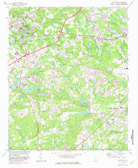
1972 Map of Lexington
USGS Topo · Published 1983About this map
Lexington serves as the hub of this Central South Carolina landscape in the early 1970s, where the suburban growth of the Springdale and South Congaree areas meets the region's traditional rural character. The map captures a transition in transport and industry, with the Southern railroad line bisecting the terrain and the Columbia Metropolitan Airport expanding on the eastern edge. Local history is deeply etched into the land through numerous rural worship centers such as Nazareth Ch, Emmanuel Ch, and St James Ch.
Find a feature on this map
47 named features on this map. Tap any name to fly to it.
Don’t see what you’re looking for? This feature index may not catch every label — zoom into the map to look around manually.
Map Details
Editions of this 1972 Lexington Map
3 editions found
Other maps of this area

1904 · Columbia
USGS Topo · 1:125,000

1941 · Spartanburg
USGS Topo · 1:250,000

1944 · Gilbert
USGS Topo · 1:62,500

1944 · Edmund
USGS Topo · 1:62,500

1946 · Irmo
USGS Topo · 1:24,000

1947 · Columbia North
USGS Topo · 1:24,000

1948 · Irmo
USGS Topo · 1:24,000

1948 · Columbia North
USGS Topo · 1:24,000

1953 · Spartanburg
USGS Topo · 1:250,000

1954 · Augusta
USGS Topo · 1:250,000