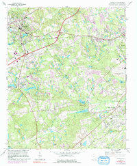
1972 Map of Lexington
USGS Topo · Published 1992About this map
Lexington serves as the focal point for this 1970s landscape, which illustrates the transition from rural agricultural land to suburban expansion. The town is flanked by a network of water bodies, including Gibsons Pond and Twelvemile Creek, while the Southern railroad line cuts across the terrain, marking the corridor for regional transit and industry. To the south, Red Bank and South Congaree appear as smaller centers of community life, surrounded by a high density of country churches such as St James Ch and Nazareth Ch.
Find a feature on this map
50 named features on this map. Tap any name to fly to it.
Don’t see what you’re looking for? This feature index may not catch every label — zoom into the map to look around manually.
Map Details
Editions of this 1972 Lexington Map
3 editions found
Other maps of this area

1904 · Columbia
USGS Topo · 1:125,000

1941 · Spartanburg
USGS Topo · 1:250,000

1944 · Gilbert
USGS Topo · 1:62,500

1944 · Edmund
USGS Topo · 1:62,500

1946 · Irmo
USGS Topo · 1:24,000

1947 · Columbia North
USGS Topo · 1:24,000

1948 · Irmo
USGS Topo · 1:24,000

1948 · Columbia North
USGS Topo · 1:24,000

1953 · Spartanburg
USGS Topo · 1:250,000

1954 · Augusta
USGS Topo · 1:250,000