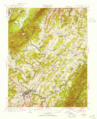
1950 Map of Lexington
USGS Topo · Published 1955About this map
Lexington sits at the confluence of several major transport routes in this mid-century view, where the Maury River meets an intricate network of early highways and rail lines. The landscape is defined by the ridge-and-valley topography of the George Washington National Forest, with Jump Mountain and Forge Mountain looming over the valleys. Small community hubs like Rockbridge Baths and Brownsburg are anchored by social foundations such as Bethesda Ch and local industry like McClung Mill.
Find a feature on this map
132 named features on this map. Tap any name to fly to it.
Don’t see what you’re looking for? This feature index may not catch every label — zoom into the map to look around manually.
Map Details
Editions of this 1950 Lexington Map
2 editions found
Other maps of this area

1894 · Staunton
USGS Topo · 1:125,000

1894 · Natural Bridge
USGS Topo · 1:125,000

1894 · Lexington
USGS Topo · 1:125,000

1894 · Natural Bridge
USGS Topo · 1:62,500

1901 · Monterey
USGS Topo · 1:125,000

1907 · Natural Bridge Special
USGS Topo · 1:62,500

1932 · Lexington
USGS Topo · 1:48,000

1935 · Buena Vista
USGS Topo · 1:48,000

1935 · Amherst
USGS Topo · 1:48,000

1936 · Vesuvius
USGS Topo · 1:48,000