
1962 Map of Lexington West
USGS Topo · Published 1964About this map
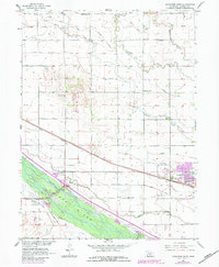
The Platte River valley in the early 1960s was a landscape defined by its intricate irrigation and transport networks, centered on the western edge of Lexington. This survey illustrates the dense infrastructure of the Missouri River Basin development, where the Dawson County Canal, Thirtymile Canal, and numerous laterals like Lateral No 1 weave through the township of Coyote. Parallel to these waterways, the Union Pacific railroad and the historic path of the Emigrant Trail trace the corridor of westward expansion.
Find a feature on this map
28 named features on this map. Tap any name to fly to it.
Don’t see what you’re looking for? This feature index may not catch every label — zoom into the map to look around manually.
Map Details
Editions of this 1962 Lexington West Map
2 editions found
Other maps of this area

1896 · Lexington
USGS Topo · 1:125,000

1899 · Lexington
USGS Topo · 1:125,000

1955 · Grand Island
USGS Topo · 1:250,000

1957 · Grand Island
USGS Topo · 1:250,000

1958 · Grand Island
USGS Topo · 1:250,000
1962 · Buffalo
USGS Topo · 1:24,000

1962 · Lexington East
USGS Topo · 1:24,000

1962 · Bertrand NW
USGS Topo · 1:24,000
1962 · Lexington NW
USGS Topo · 1:24,000
1971 · Johnson Lake
USGS Topo · 1:24,000