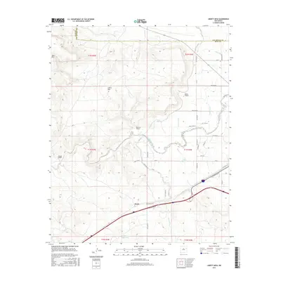
2017 Map of Liberty Mesa
USGS Topo · Published 2017About this map
Liberty Mesa and the massive landform of Mesa Rica dominate the high-desert topography of this region west of Tucumcari. The landscape is defined by a network of drainage systems including Pajarito Cr and Bluewater Cr, which have carved notable features such as Pajarito Canyon and Dickie Canyon. The settlement at Hargis sits along the southern transport corridor where W Tucumcari Blvd and Five Mile Park Rd converge. This area reflects a reliance on managed water in an arid environment, evidenced by the Bell Lateral and Liberty Lateral irrigation channels. Smaller water features like the Blue Hole and Middle Pasture Tank suggest localized points of importance for ranching and travelers moving across the high plains of Quay and San Miguel counties.
Find a feature on this map
32 named features on this map. Tap any name to fly to it.
Don’t see what you’re looking for? This feature index may not catch every label — zoom into the map to look around manually.
Map Details
Editions of this 2017 Liberty Mesa Map
This is the sole edition of this map. No revisions or reprints were ever made.
Other maps of this area

1930 · Tucumcari
USGS Topo · 1:125,000

1954 · Tucumcari
USGS Topo · 1:250,000

1958 · Tucumcari
USGS Topo · 1:250,000

1967 · Trinchera Creek
USGS Topo · 1:24,000

1967 · Liberty Mesa
USGS Topo · 1:24,000

1967 · Tucumcari
USGS Topo · 1:24,000
1968 · Quemado Hills
USGS Topo · 1:24,000

1968 · Bascom Camp
USGS Topo · 1:24,000

1968 · Bulldog Mesa
USGS Topo · 1:24,000

1968 · Carpenter Mesa SW
USGS Topo · 1:24,000