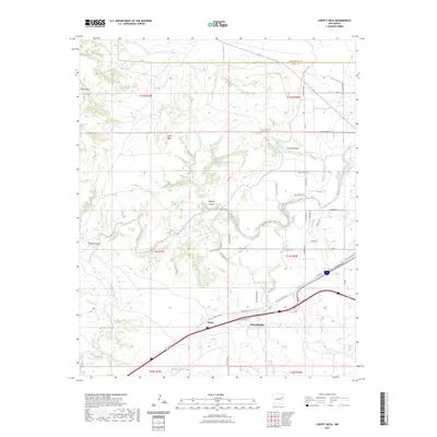
2023 Map of Liberty Mesa
USGS Topo · Published 2023About this map
Tucumcari and its surrounding high plains landscape are defined by striking geological formations and a network of managed water. The elevation rises sharply toward the plateau of Liberty Mesa and the northern escarpment of Mesa Rica, while the drainage system of Pajarito Creek and Trinchera Creek carves through the terrain. The presence of features like Blue Hole and the Middle Pasture Tank reflect the importance of water resources in this arid environment.
Find a feature on this map
47 named features on this map. Tap any name to fly to it.
Don’t see what you’re looking for? This feature index may not catch every label — zoom into the map to look around manually.
Map Details
Editions of this 2023 Liberty Mesa Map
This is the sole edition of this map. No revisions or reprints were ever made.
Other maps of this area

1930 · Tucumcari
USGS Topo · 1:125,000

1954 · Tucumcari
USGS Topo · 1:250,000

1958 · Tucumcari
USGS Topo · 1:250,000

1967 · Trinchera Creek
USGS Topo · 1:24,000

1967 · Liberty Mesa
USGS Topo · 1:24,000

1967 · Tucumcari
USGS Topo · 1:24,000
1968 · Quemado Hills
USGS Topo · 1:24,000

1968 · Bascom Camp
USGS Topo · 1:24,000

1968 · Bulldog Mesa
USGS Topo · 1:24,000

1968 · Carpenter Mesa SW
USGS Topo · 1:24,000