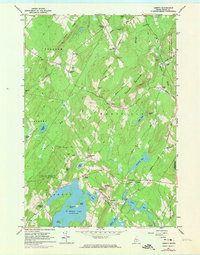
1961 Map of Liberty
USGS Topo · Published 1974About this map
St George Lake serves as a central landmark for this Waldo County area, with Lake St George State Park and Haystack Mountain overlooking its northern shores. The 1961 field check, updated with 1973 revisions, reveals a landscape defined by small rural settlements and family-named intersections such as Thurstons Corner, Polands Corner, and Clarks Corner. These communities are connected by a network of local routes like Mason Hill Road and Thompson Ridge Rd, winding through the hills between Freedom and Montville.
Find a feature on this map
64 named features on this map. Tap any name to fly to it.
Don’t see what you’re looking for? This feature index may not catch every label — zoom into the map to look around manually.
Map Details
Editions of this 1961 Liberty Map
4 editions found
Other maps of this area

1915 · Belfast
USGS Topo · 1:62,500

1916 · Liberty
USGS Topo · 1:62,500

1917 · Belfast
USGS Topo · 1:62,500

1926 · Burnham
USGS Topo · 1:62,500

1932 · Brooks
USGS Topo · 1:62,500

1941 · Belfast
USGS Topo · 1:62,500

1942 · Liberty
USGS Topo · 1:62,500

1948 · Bangor
USGS Topo · 1:250,000

1950 · Belfast
USGS Topo · 1:50,000

1950 · Liberty
USGS Topo · 1:50,000