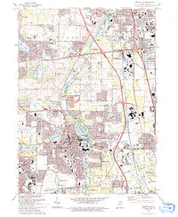
1993 Map of Libertyville
USGS Topo · Published 1993About this map
The Des Plaines River corridor anchors this landscape, winding south through an extensive network of County Forest Preserve lands and recreation sites. By the early 1990s, the region shows the dense intersection of suburban growth and institutional presence, particularly with the sprawling Naval Training Center and the Lakehurst Shopping Center marking the edges of Waukegan. Local heritage is well-documented through numerous religious and educational landmarks, including the St Sava Camp, Bible Ch, and Carmel High Sch. Transportation networks are equally prominent, with the Tri-State Tollway and rail lines like the Soo Line RR facilitating movement through Libertyville and Gurnee. Smaller water bodies like Butler Lake and Lake Charles dot the residential landscape, while large memorial sites such as Ascension Cemetery and Highland Mem Park (Cem) occupy significant acreage between the expanding settlements.
Find a feature on this map
71 named features on this map. Tap any name to fly to it.
Don’t see what you’re looking for? This feature index may not catch every label — zoom into the map to look around manually.
Map Details
Editions of this 1993 Libertyville Map
This is the sole edition of this map. No revisions or reprints were ever made.
Other maps of this area

1900 · Highwood
USGS Topo · 1:62,500

1906 · Waukegan
USGS Topo · 1:62,500

1908 · Waukegan
USGS Topo · 1:62,500

1920 · Grays Lake
USGS Topo · 1:62,500

1923 · Grays Lake
USGS Topo · 1:62,500

1923 · Barrington
USGS Topo · 1:62,500

1928 · Wheeling
USGS Topo · 1:24,000

1928 · Highland Park
USGS Topo · 1:24,000

1935 · Barrington
USGS Topo · 1:62,500

1951 · Highland Park
USGS Topo · 1:24,000