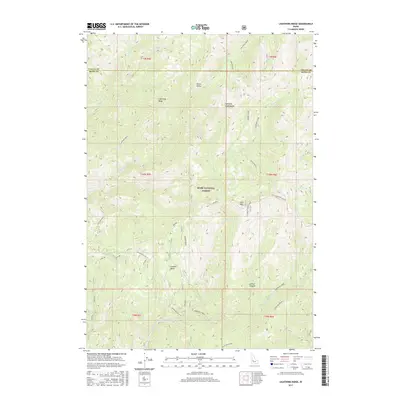
2017 Map of Lightning Ridge
USGS Topo · Published 2017About this map
The high ridgelines of the Boise National Forest dominate this terrain on the border of Valley and Boise counties. Lightning Ridge bisects the northern half of the area, flanked by Onion Valley and the prominent Lightning Creek Rocks. This landscape is defined by its drainages and peaks, including the 8,215-foot summit of Scott Mtn, which serves as a primary geographic anchor.
Find a feature on this map
32 named features on this map. Tap any name to fly to it.
Don’t see what you’re looking for? This feature index may not catch every label — zoom into the map to look around manually.
Map Details
Editions of this 2017 Lightning Ridge Map
This is the sole edition of this map. No revisions or reprints were ever made.
Other maps of this area

1909 · Garden Valley
USGS Topo · 1:125,000

1953 · Boiling Springs
USGS Topo · 1:62,500

1953 · Deadwood Reservoir
USGS Topo · 1:62,500

1957 · Challis
USGS Topo · 1:250,000

1959 · Garden Valley
USGS Topo · 1:62,500

1960 · Challis
USGS Topo · 1:250,000

1963 · Challis
USGS Topo · 1:250,000

1972 · Scott Creek
USGS Topo · 1:24,000
1972 · Pine Flat
USGS Topo · 1:24,000

1982 · Deadwood River
USGS Topo · 1:100,000