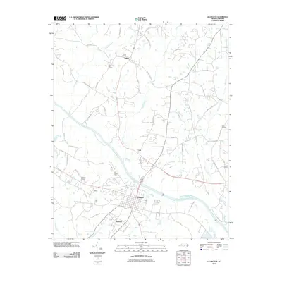
2010 Map of Lillington
USGS Topo · Published 2010About this map
Lillington serves as the focal point of this Harnett County survey, positioned along the northern banks of the Cape-Fear-River. The landscape is defined by the winding paths of Neills Creek and Dry Creek, which flow through a network of small settlements and family lands. Historical continuity is evident in the numerous burial grounds scattered across the area, including Smith Cemetery and Olive Branch Cemetery near the community of Kipling, and Harnett Memorial Cemetery closer to the town center. Local infrastructure and community markers like the A J White Dam, the Tirzah Airport, and the southern neighborhood of Shawtown illustrate the late 20th-century development of this riverside region. The map captures a mix of residential growth and established agricultural tracts, connected by a web of rural routes such as Matthews Rd and Nathan Matthews Rd, reflecting long-standing local lineage in the territory north of the Cape Fear River.
Find a feature on this map
60 named features on this map. Tap any name to fly to it.
Don’t see what you’re looking for? This feature index may not catch every label — zoom into the map to look around manually.
Map Details
Editions of this 2010 Lillington Map
This is the sole edition of this map. No revisions or reprints were ever made.
Other maps of this area

1953 · Raleigh
USGS Topo · 1:250,000

1954 · Raleigh
USGS Topo · 1:250,000

1956 · Anderson Creek
USGS Topo · 1:24,000

1956 · Bunnlevel
USGS Topo · 1:24,000

1964 · Angier
USGS Topo · 1:24,000

1964 · Garner
USGS Topo · 1:62,500

1973 · Erwin
USGS Topo · 1:24,000

1973 · Coats
USGS Topo · 1:24,000
1974 · Fuquay-Varina
USGS Topo · 1:24,000

1974 · Mamers
USGS Topo · 1:24,000