
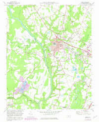
1973 Map of Erwin
USGS Topo · Published 1975About this map
The Cape Fear River and Little River converge in this mid-1970s landscape, marking the boundary between Harnett Co and Cumberland Co. The town of Erwin serves as a central hub, defined by its textile heritage and connection to the Durham and Southern railway. Further south, the map documents the Averasboro Cem, a significant site reflecting the area's deeper history. The settlement pattern is largely rural and ecclesiastical, with community anchors like Turlington Grove Ch, Porters Chapel, and Erwin Chapel scattered across the farmland. Transportation is dominated by a complex rail network including the Seaboard Coast Line and Norfolk Southern, which supported the local industrial infrastructure visible at the filtration plants and gravel pits near Dunn.
Find a feature on this map
37 named features on this map. Tap any name to fly to it.
Don’t see what you’re looking for? This feature index may not catch every label — zoom into the map to look around manually.
Map Details
Editions of this 1973 Erwin Map
2 editions found
Other maps of this area

1948 · Fayetteville
USGS Topo · 1:62,500

1948 · Slocomb
USGS Topo · 1:24,000

1950 · Slocomb
USGS Topo · 1:24,000

1953 · Raleigh
USGS Topo · 1:250,000

1954 · Raleigh
USGS Topo · 1:250,000

1956 · Bunnlevel
USGS Topo · 1:24,000

1957 · Fayetteville
USGS Topo · 1:62,500

1973 · Benson
USGS Topo · 1:24,000

1973 · Dunn
USGS Topo · 1:24,000

1973 · Coats
USGS Topo · 1:24,000