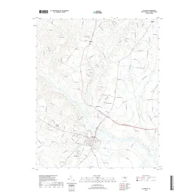
2019 Map of Lillington
USGS Topo · Published 2019About this map
The Cape Fear River anchors this 2019 survey of Harnett County, flowing southeastward through the heart of Lillington, where the street grid of the county seat meets the river's edge. The surrounding landscape is a complex network of small rural communities and family-named landmarks, such as Kipling and Shawtown, interspersed with numerous family cemeteries like Smith Cem and Olive Branch Cem. These sites, along with larger grounds like Harnett Memorial Cem, suggest a deeply rooted settlement pattern that has persisted even as modern infrastructure like the W Cornelius Harnett Blvd corridor expands. To the north, the terrain is defined by the drainage basins of Hector Cr and Neills Cr, while the edge of Angier appears at the northern margin. The map preserves the specific locations of several local landmarks, including Johnson Field, documenting the transition between historic agricultural lands and contemporary North Carolina development.
Find a feature on this map
124 named features on this map. Tap any name to fly to it.
Don’t see what you’re looking for? This feature index may not catch every label — zoom into the map to look around manually.
Map Details
Editions of this 2019 Lillington Map
This is the sole edition of this map. No revisions or reprints were ever made.
Other maps of this area

1953 · Raleigh
USGS Topo · 1:250,000

1954 · Raleigh
USGS Topo · 1:250,000

1956 · Anderson Creek
USGS Topo · 1:24,000

1956 · Bunnlevel
USGS Topo · 1:24,000

1964 · Angier
USGS Topo · 1:24,000

1964 · Garner
USGS Topo · 1:62,500

1973 · Erwin
USGS Topo · 1:24,000

1973 · Coats
USGS Topo · 1:24,000
1974 · Fuquay-Varina
USGS Topo · 1:24,000

1974 · Mamers
USGS Topo · 1:24,000