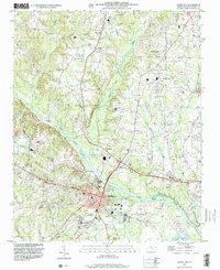
1997 Map of Lillington
USGS Topo · Published 2000About this map
The Cape Fear River bisects this late-twentieth-century landscape, anchoring the development of Lillington as the primary hub of Central North Carolina's Harnett County. The town's grid and municipal facilities, such as the Sewage Disposal Ponds and the nearby Dept of Corrections, are shown in detail alongside established residential areas like Shawtown. The land use transitions from the concentrated civic center to more rural outposts including Kipling and Cape Fear, where community life is organized around sites like Harnett Central High School and North Harnett Sch.
Find a feature on this map
40 named features on this map. Tap any name to fly to it.
Don’t see what you’re looking for? This feature index may not catch every label — zoom into the map to look around manually.
Map Details
Editions of this 1997 Lillington Map
This is the sole edition of this map. No revisions or reprints were ever made.
Other maps of this area

1953 · Raleigh
USGS Topo · 1:250,000

1954 · Raleigh
USGS Topo · 1:250,000

1956 · Anderson Creek
USGS Topo · 1:24,000

1956 · Bunnlevel
USGS Topo · 1:24,000

1964 · Angier
USGS Topo · 1:24,000

1964 · Garner
USGS Topo · 1:62,500

1973 · Erwin
USGS Topo · 1:24,000

1973 · Coats
USGS Topo · 1:24,000
1974 · Fuquay-Varina
USGS Topo · 1:24,000

1974 · Mamers
USGS Topo · 1:24,000