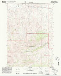
1997 Map of Lima Peaks
USGS Topo · Published 2002About this map
Lima Peaks dominate this high-altitude landscape along the southwestern edge of Montana, where the Continental Divide winds through the Beaverhead National Forest. This late-twentieth-century survey documents the headwaters of numerous streams, including Birch Creek and Little Sheep Creek, which drain from the slopes of Garfield Mountain. The presence of the Deep Creek Cow Camp near Deep Creek and the Dillon Ranger District boundary reflects the ongoing importance of livestock grazing and federal land management in this remote region. A network of springs, such as Sawmill Spring and Lower Deep Creek Spring, provide vital water points in a terrain marked by steep gulches like Dutch Hollow Creek and Crooked Run. The map provides a precise record of the natural topography and primitive access routes before the turn of the millennium.
Find a feature on this map
25 named features on this map. Tap any name to fly to it.
Don’t see what you’re looking for? This feature index may not catch every label — zoom into the map to look around manually.
Map Details
Editions of this 1997 Lima Peaks Map
This is the sole edition of this map. No revisions or reprints were ever made.
Other maps of this area

1955 · Dubois
USGS Topo · 1:250,000

1957 · Paul Reservoir
USGS Topo · 1:62,500

1957 · Edie Ranch
USGS Topo · 1:62,500

1958 · Dubois
USGS Topo · 1:250,000

1965 · Gallagher Gulch
USGS Topo · 1:24,000

1965 · Lima
USGS Topo · 1:24,000

1965 · Dell
USGS Topo · 1:24,000

1965 · Lima Peaks
USGS Topo · 1:24,000

1968 · Snowline
USGS Topo · 1:24,000

1968 · Henry Gulch
USGS Topo · 1:24,000