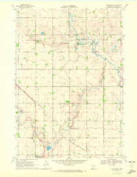
1970 Map of Lime Creek
USGS Topo · Published 1972About this map
The Chicago and North Western railroad cuts a diagonal path through this corner of Murray County, connecting the grain-growing landscape of Bondin and Belfast townships. At the southern edge, the town of Fulda serves as a local hub, featuring a Nursing Home, a Radio Tower, and the Sewage Disposal Ponds. The rural character of the area is underscored by the presence of multiple Gravel Pit locations and the meandering course of the Des Moines River to the north and east. For those researching family history, the map precisely locates Prairie Hill Cem and St Gabriel Cem. Significant acreage is dedicated to conservation, with both the Irruption State Wildlife Management Area and the Haberman State Wildlife Management Area protecting the prairie wetlands and watercourses like Bondin Creek and the namesake Lime Creek.
Find a feature on this map
22 named features on this map. Tap any name to fly to it.
Don’t see what you’re looking for? This feature index may not catch every label — zoom into the map to look around manually.
Map Details
Editions of this 1970 Lime Creek Map
This is the sole edition of this map. No revisions or reprints were ever made.
Other maps of this area

1953 · New Ulm
USGS Topo · 1:250,000

1954 · Fairmont
USGS Topo · 1:250,000

1957 · New Ulm
USGS Topo · 1:250,000

1958 · New Ulm
USGS Topo · 1:250,000

1958 · Fairmont
USGS Topo · 1:250,000

1967 · New Ulm
USGS Topo · 1:250,000

1967 · Dovray
USGS Topo · 1:24,000
1967 · Currie
USGS Topo · 1:24,000
1967 · Westbrook
USGS Topo · 1:24,000

1970 · Heron Lake NW
USGS Topo · 1:24,000