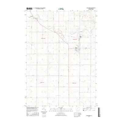
2015 Map of Lime Springs
USGS Topo · Published 2015About this map
Lime Springs and the village of Chester anchor this Howard County landscape, where the Upper Iowa River cuts a winding course across the northern terrain. The area is defined by a dense grid of rural township roads and the convergence of several significant waterways, including Beaver Cr and the headwaters of the Turkey River system. Historical interest centers on Lidtke Mill along the river banks north of Lime Springs, a site reflecting the early industrial reliance on local water power. Further east, Pleasant Hill Cem serves as a primary genealogical landmark for the surrounding farming community. The map's detailed topography illustrates the transition between the river valleys and the higher agricultural plains, segmented by the southern branches of the N Br Turkey River and W Br Turkey River.
Find a feature on this map
51 named features on this map. Tap any name to fly to it.
Don’t see what you’re looking for? This feature index may not catch every label — zoom into the map to look around manually.
Map Details
Editions of this 2015 Lime Springs Map
This is the sole edition of this map. No revisions or reprints were ever made.
Other maps of this area

1954 · Mason City
USGS Topo · 1:250,000

1957 · Mason City
USGS Topo · 1:250,000

1958 · Mason City
USGS Topo · 1:250,000

1965 · Greenleafton
USGS Topo · 1:24,000

1965 · Ostrander
USGS Topo · 1:24,000

1965 · Cherry Grove
USGS Topo · 1:24,000

1981 · Lourdes
USGS Topo · 1:24,000

1981 · Cresco NW
USGS Topo · 1:24,000

1981 · Lime Springs
USGS Topo · 1:24,000
1981 · Cresco SW
USGS Topo · 1:24,000