
1981 Map of Lime Springs
USGS Topo · Published 1982About this map
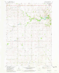
The Upper Iowa River carves a winding path through this northern Iowa landscape, anchored by the settlement of Lime Springs and the village of Chester near the Minnesota border. This 1981 survey reflects a rural corridor defined by agricultural boundaries and the prominent line of the Chicago Milwaukee St Paul and Pacific railroad, which parallels the river valley. Local recreation and preservation are evident at Lidtke County Park, where the river’s course provides a natural focal point for the community. In the southern portion of the map, the terrain levels out across Saratoga and Howard Center, where the headwaters of the West Branch Turkey River begin to emerge. Genealogists will find the Pleasant Hill Cem clearly marked near the eastern edge, while numerous quarries and gravel pits scattered across the township indicate the local importance of aggregate mining during this era.
Find a feature on this map
25 named features on this map. Tap any name to fly to it.
Don’t see what you’re looking for? This feature index may not catch every label — zoom into the map to look around manually.
Map Details
Editions of this 1981 Lime Springs Map
This is the sole edition of this map. No revisions or reprints were ever made.
Other maps of this area

1954 · Mason City
USGS Topo · 1:250,000

1957 · Mason City
USGS Topo · 1:250,000

1958 · Mason City
USGS Topo · 1:250,000

1965 · Greenleafton
USGS Topo · 1:24,000

1965 · Ostrander
USGS Topo · 1:24,000

1965 · Cherry Grove
USGS Topo · 1:24,000

1981 · Lourdes
USGS Topo · 1:24,000

1981 · Cresco NW
USGS Topo · 1:24,000
1981 · Cresco SW
USGS Topo · 1:24,000
1981 · Lime Springs NW
USGS Topo · 1:24,000