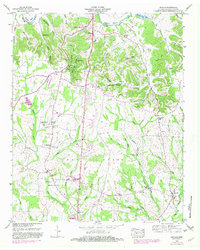
1949 Map of Lincoln
USGS Topo · Published 1982About this map
Fayetteville anchors the northern reaches of this mid-century survey, situated along a prominent bend in the Elk River. The landscape transitions from the river valley southward across the broad expanse of Pear Ridge toward the smaller settlement of Lincoln near the Flint River. This area is marked by a high density of family-named landmarks and rural infrastructure, including numerous cemeteries like Wells Hill Cem and Simms Cem.
Find a feature on this map
79 named features on this map. Tap any name to fly to it.
Don’t see what you’re looking for? This feature index may not catch every label — zoom into the map to look around manually.
Map Details
Editions of this 1949 Lincoln Map
3 editions found
Other maps of this area

1888 · Scottsboro
USGS Topo · 1:125,000

1888 · Huntsville
USGS Topo · 1:125,000

1892 · Huntsville
USGS Topo · 1:125,000

1892 · Scottsboro
USGS Topo · 1:125,000

1936 · Flintville
USGS Topo · 1:24,000

1936 · Taft
USGS Topo · 1:24,000

1936 · Fisk
USGS Topo · 1:24,000

1936 · Boonshill
USGS Topo · 1:24,000

1936 · Lincoln
USGS Topo · 1:24,000

1936 · Toney
USGS Topo · 1:24,000