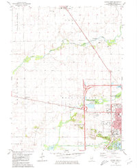
1980 Map of Lincoln West
USGS Topo · Published 1980About this map
Lincoln and its western rural stretches are defined by a network of waterways including Kickapoo Creek, Sugar Creek, and Salt Creek. The landscape transition from the town's expanding residential grid to the surrounding townships of Orvil, Sheridan, and West Lincoln is marked by a mix of civic institutions and industrial utility. The Lincoln Gas Storage Area and various gravel pits and quarries contrast with recreational spaces like Railsplitter State Park and Memorial Park. For local history researchers, the map reveals numerous family and community burial grounds such as Musick Cem, Rimerman Cem, and Union Cemetery. Infrastructure of the late 20th century is well-documented, from the Illinois Central Gulf railroad line to the Lincoln Development Center and local schools like Melrose Park Sch.
Find a feature on this map
37 named features on this map. Tap any name to fly to it.
Don’t see what you’re looking for? This feature index may not catch every label — zoom into the map to look around manually.
Map Details
Editions of this 1980 Lincoln West Map
This is the sole edition of this map. No revisions or reprints were ever made.
Other maps of this area

1911 · Lincoln
USGS Topo · 1:62,500

1913 · Lincoln
USGS Topo · 1:62,500

1942 · Delavan
USGS Topo · 1:62,500

1948 · Mason City
USGS Topo · 1:62,500

1949 · Mason City
USGS Topo · 1:62,500

1951 · Minier
USGS Topo · 1:62,500

1958 · Peoria
USGS Topo · 1:250,000

1961 · Peoria
USGS Topo · 1:250,000

1963 · Peoria
USGS Topo · 1:250,000

1980 · Armington
USGS Topo · 1:24,000