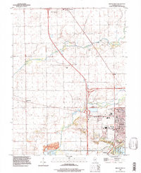
1996 Map of Lincoln West
USGS Topo · Published 1997About this map
The city of Lincoln and the agricultural lands of Logan County are captured here in the mid-1990s, revealing a landscape defined by both historic preservation and modern utility. The Postville Court House State Historic Site stands as a focal point in the city, marking its legacy as the seat of justice where Abraham Lincoln once practiced law. This intersection of history and development is further evidenced by the Lincoln Gas Storage Area and the extensive Gravel Pit operations near Kickapoo Creek. Numerous rural burial grounds like Schrader Cem and Musick Cem are scattered across the townships of Orvil and West Lincoln, offering vital coordinates for genealogists. The southern portion of the sheet highlights the transition to recreational land use at Ed Madigan State Park and the varied shoreline of Lincoln Lakes near Salt Creek.
Find a feature on this map
40 named features on this map. Tap any name to fly to it.
Don’t see what you’re looking for? This feature index may not catch every label — zoom into the map to look around manually.
Map Details
Editions of this 1996 Lincoln West Map
This is the sole edition of this map. No revisions or reprints were ever made.
Other maps of this area

1911 · Lincoln
USGS Topo · 1:62,500

1913 · Lincoln
USGS Topo · 1:62,500

1942 · Delavan
USGS Topo · 1:62,500

1948 · Mason City
USGS Topo · 1:62,500

1949 · Mason City
USGS Topo · 1:62,500

1951 · Minier
USGS Topo · 1:62,500

1958 · Peoria
USGS Topo · 1:250,000

1961 · Peoria
USGS Topo · 1:250,000

1963 · Peoria
USGS Topo · 1:250,000

1980 · Armington
USGS Topo · 1:24,000