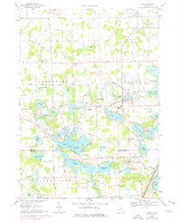
1969 Map of Linden
USGS Topo · Published 1976About this map
The Shiawassee River winds through a chain of lakes across this Genesee and Livingston County landscape, anchoring the village of Linden. The late 1960s terrain is characterized by its complex hydrology, where large water bodies like Lobdell Lake, Byram Lake, and Hoisington Lake are connected by the river and numerous smaller basins. The Grand Trunk Western railroad provides a primary industrial corridor through Linden, passing near the Jr High Sch and Fairview Cem. To the southwest, the settlement of Argentine sits at the confluence of several lakes, including McCaslin Lake and Softwater Lake. This survey captures the transition of the lakefronts, showing early suburban density near the water alongside traditional rural markers like Kimball Cem and Clough Hill Cem. Local aviation is noted via the Cole Port Landing Strip and another private Landing Strip south of Linden.
Find a feature on this map
68 named features on this map. Tap any name to fly to it.
Don’t see what you’re looking for? This feature index may not catch every label — zoom into the map to look around manually.
Map Details
Editions of this 1969 Linden Map
3 editions found
Other maps of this area

1907 · Howell
USGS Topo · 1:62,500

1909 · Howell
USGS Topo · 1:62,500

1909 · Milford
USGS Topo · 1:62,500

1920 · Holly
USGS Topo · 1:62,500

1922 · Holly
USGS Topo · 1:62,500

1922 · Durand
USGS Topo · 1:62,500

1943 · Holly
USGS Topo · 1:62,500

1943 · Durand
USGS Topo · 1:62,500

1954 · Detroit
USGS Topo · 1:250,000

1961 · Detroit
USGS Topo · 1:250,000