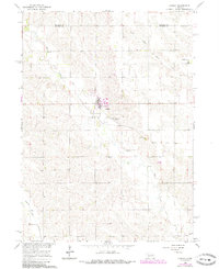
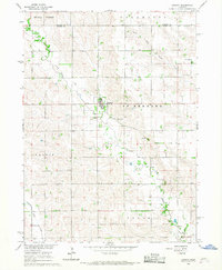
1966 Map of Lindsay
USGS Topo · Published 1985About this map
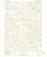
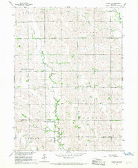
Lindsay serves as the central hub of this agricultural landscape, where the grain-handling facilities and street grid stand in contrast to the surrounding section lines and meandering creek beds. The area is defined by the drainage systems of Shell Creek, Union Creek, and Looking Glass Creek, which carve gentle valleys through the prairie. Genealogists will find a wealth of specific landmarks, including Holy Family Cem just south of the main townsite and the rural St Pauls Cem near the northern county line. The map captures a moment of transition in local transportation, clearly marking an Old Railroad Grade and other sections of Railroad Grade where tracks once connected these Nebraska communities. To the northeast, the small settlement of St Bernard remains anchored by the St Bernard Cem, while the Looking Glass Sch in the southwest corner marks a vanished center of rural education.
Find a feature on this map
13 named features on this map. Tap any name to fly to it.
Don’t see what you’re looking for? This feature index may not catch every label — zoom into the map to look around manually.
Map Details
Editions of this 1966 Lindsay Map
2 editions found
Other maps of this area

1955 · Fremont
USGS Topo · 1:250,000

1957 · Fremont
USGS Topo · 1:250,000

1958 · Fremont
USGS Topo · 1:250,000
1958 · St. Edward
USGS Topo · 1:24,000
1963 · Closter SE
USGS Topo · 1:24,000
1963 · Battle Creek SE
USGS Topo · 1:24,000
1963 · Battle Creek SW
USGS Topo · 1:24,000
1966 · Newman Grove
USGS Topo · 1:24,000
1966 · Tarnov
USGS Topo · 1:24,000
1966 · Lindsay SW
USGS Topo · 1:24,000